Pictorial Landscapes : Perspectives and points of view
Interpretations, connotations and evolving relationships integral to the discipline
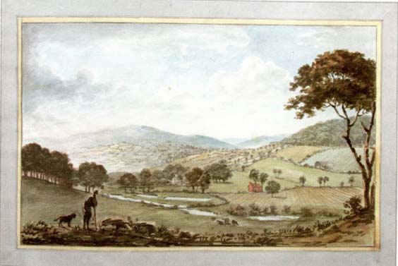
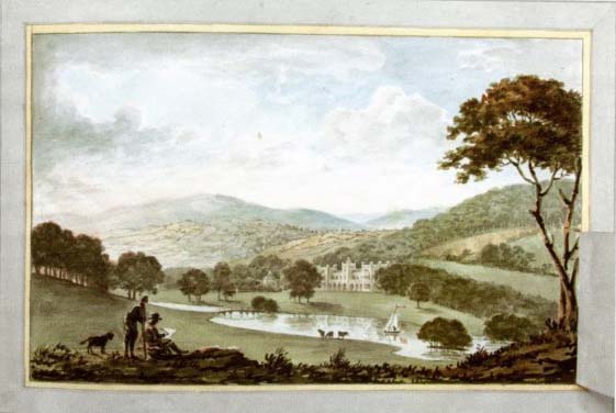
Before and After, 18th century
Drawing created fro clients and catalogued in the ‘Red Book’ or a red leather-bound book that later served as an archive for the projects of Humphry Rephton (1752 – 1818). The book contained documentation of existing site conditions contrasted with his proposals which were presented to his clients.
“Is Landscape Architecture?” – a question posed by Garret Eckbo, American Landscape Architect in the 20th century, creates the foundation for a discussion that attempts to unravel several relationships. For example, how is architecture essential to landscape, the discipline, practice and perception that shapes urban and non-urban environments?
Theorists have deliberated over the relationship between Landscape and Architecture. Humphrey Rephton and John Claudius Loudon in England, along with Antoine-Chrysostome Quatremere, de Quincy in France and Andrew Jackson Downing in the United States are among those who aimed to focus on the relations between the two, their similarities and distinctions.
With an effort to create an evolving definition of the field, the notion of landscape, its relations and connotations have been deconstructed to create an expansive and holistic understanding of its role and relevance.
The routes of a forest were compared to streets of a town by Abbé Laurier and William Chambers analysed a building’s facade from a landscape perspective.
Routes of a Forest, Streets of a Town, Abbe Laurier
The building’s facade from a landscape perspective, William Chambers
David Leatherbarrow seeks to present landscape as integral to the discipline of architecture and asserts that to perceive them independently would create an abstraction of both. This distinction, in his opinion would be inadequate to the understanding of landscape as a component situated within urban and rural contexts.
To reiterate, he emphasises that designing buildings and cities is related to the environment, topography and territory.
In comparison to the discipline of architecture, the professional history of Landscape has been considerably short. Similarly, the theory on landscape relative to architecture is limited. Literature on landscape dates back to three centuries in the Western tradition while that of architecture is 3 to 4 times more. More recently however, this dynamic, with architecture as the superior discipline has been reversed. Today, architecture relies heavily on techniques integral to the discipline and practice of Landscape. Methods such as surveying and mapping, the transformative effect of time, with a foundation in landscape has been incorporated within architectural vocabulary, pedagogy and practice.
Intersections
Topography can be discussed as the site of mediation between landscape and architecture. In his essay, Leatherbarrow seeks to offer a new dimension to relate both fields. The argument presents landscape and architecture as interrelated disciplines, reflecting the dichotomous role of nature and culture in the design of cities.
The author states, landscape and architecture have been integral to the understanding of culture. In this regard, landscape and urban design literature illustrate different forms of representations. For example, gardens and buildings have have been likened to other forms of cultural productions such as poetry, philosophy or politics.
Topography has been employed as a theme or framework to offer a common ground for understanding the relations between architecture, urban design and landscape, and their role in the production of contemporary culture. He characterises the three practices as “topographical arts” that “provide the prosaic patterns of our lives with the durable dimension and beautiful expression.” This use of the term implies a broader understanding extending beyond the conventional definition of topography as related specifically to land. By this definition, topography incorporates the – terrain, the built and the unbuilt. It implies a certain readability of the land and the architectural object toward an territorial understanding of occupation.
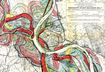
Mississippi river, Changing course, shifting land mass and settlement patterns in history
Legible and Temporal
Through observation, understanding and analysis, the physical condition of a site, and the objects present on it can be used to create a history of the land and determine its influence on its present state. As noted by the author, “(…) land is not only soil, but all that is hidden beneath it and emerges from it, as well as the several agencies that sustain that emergence.” The events, historical and practical, determine the nature of a site and situate it in the present context. In this regard, the author notes, “Topographical inscriptions, do indeed, give evidence of previous enactments but they also indicate those that are still occurring and that may unfold in future.”
The temporality of the landscape is evident in the materials that create it, and their tendency to constantly renew themselves. This process of renewal, or metabolism that you all are familiar with, is important for the site to remain operational; to continue to function as a space for architecture.
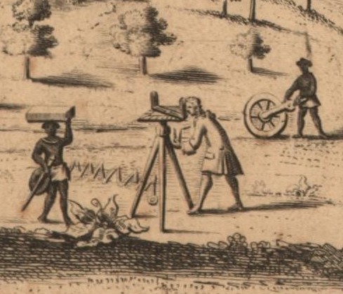
Surveying and Mapping techniques, ‘Scientific Revolution,’
Records and Calculations for cannon fire trajectories
in the design of fortifications
Material
The use of topography as a parameter to measure the degree of influence of landscape on architecture and vice versa is evident in multiple aspects that guide design and construction. For example, material composition, temperature, colour, thickness, texture and luminosity are factors that relate to the physical site and influence architectural production. This use of topography establishes the significance of profile, orientation and configuration of land on architecture.
Spatial and Pictorial
Topography functions as a form of representation; it is a useful in expression, in illustrating associations and creating images. The spatial aspects of land are as important as its physical qualities which contribute to the shaping of its architecture. The spatial components of a place include elements such as enclosure, continuity and extent which indicate the potential of the land to be occupied and used. These factors contribute to both the image and functional potential of a place.
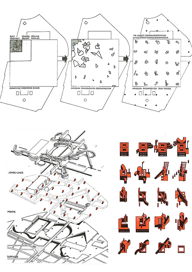
Case studies that illustrate this expansive definition and use of Landscape include Le Corbusier’s plan for the Venice Hospital in 1965 and is interwoven design language between land, seascape and architecture which relate a collective definition of the urban.
A more recent example is Bernard Tschumi’s Parc de la Villette of the 1980s. The project integrates and bases its programmatic composition on the pre-existing urban condition, demonstrating the relevance of the site on the design and phased development.
The mat buildings of Allison and Peter Smithson, the Kuwait project, 1969, Corbusier’s work in Chandigarh, the Radiant Farm and the Cooperative Village are other examples that illustrate the indispensability of the natural environment. The Parkway project in Philadelphia by Jacques Greber and Paul Cret reflects the design ideology evident in the work of Tony Garnier in Cite Industrielle, 1917 synchronising architecture, landscape and urban infrastructure.
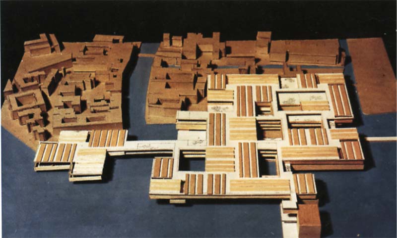
Mat Buildings: The Venice Hospital Project, Le Corbusier, 1965
Ideological and Practical
Contemporary notions of landscape reject distinctions between nature and culture. Instead, landscape is used to denote a combination of both.
The term “Landscape” is understood as “Land” that is a material expanse, naturally existing and “scape” – the image or effect produced through action. The distinction between naturally occurring terrain and landscape that is materially or operationally produced fails to consider the temporal quality of the land wherein land naturally renews itself periodically and is a product of its past use. Therefore, the idea of land solely as a natural resource does not consider its continuity based on responsive action. So, it assumes that land does not change with the impact of time and varied climatic conditions.
Consequently, a removal of this distinction also transforms the assumption that the user has the right to a material world, the urban context as opposed to the natural environment. Therefore, both the built and natural environment, by this definition, are accessible to the user. This understanding of landscape, built form and topography attempts to present an integration of human and natural processes. The perception influences an assemblage of institutions, forms and practices that shape everyday life.
Additionally, the ownership of land that confines its limit and creates segregation has been rejected in current theory. Here, the notion of landscape extends to both site and terrain extending beyond a plot line or boundary, approaching the horizon.
The contemporary understanding perceives “land” as both natural and creative. “Scape” refers to the view, the canvas or the background as well as the ideology behind the perception ; the way of seeing.
The notion of Landscape as a way of seeing first emerged in the fifteenth and early sixteenth centuries from renaissance humanism and its conceptualisation of space.
Humanism served to function as a force of opposition to the objectified and mechanical aspects of relations between the environment, the built form and the user formed during the seventeenth century scientific revolution. On the other hand, the scientific revolution aimed to reinforce precision and objective views to the discipline making it quantifiable as a precise science. Renaissance humanism and the scientific revolution presented two sides of the same coin that the discipline in more recent years has aimed to combine holistically in theory and practice. In this regard, Landscape combined scientific and humanistic aspects in the study of the environment.
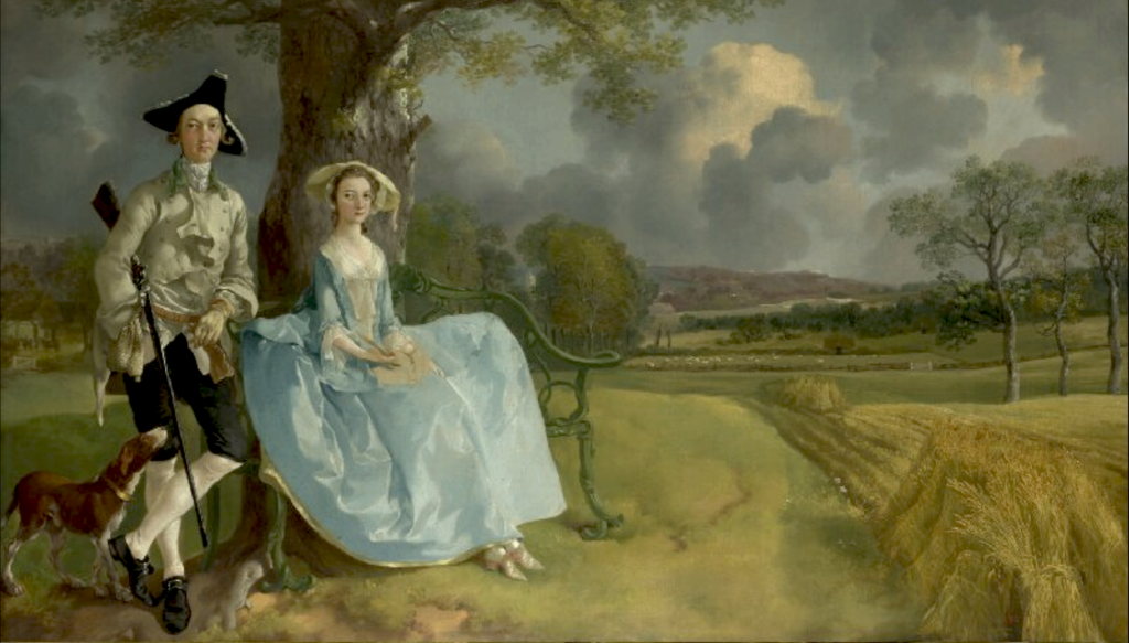
Mr. and Mrs. Andrews, 1850. Thomas Gainsborough. Humanism through Painting and Garden Design,
encapsulating the pictorial, the aesthetic and the narrational aspects of art.
Painting and garden design served as means of visual and ideological framing aspects of landscape that theoretically established its role while methods such as mapping and surveying pursued its application practically.
These techniques employed in the study of commercial estates acquired by the urban bourgeoisie, to make calculations such as distance, trajectories for cannon fire, and in the creation of defensive fortifications. The methods also helped cosmographers and choreographers in projecting maps that served as devices that introduced Europe to the world.
Landscape as a discipline and practice over the course of history has represented distinct ways of seeing through spatial compositions ordered on geometry. The field has retained its relevance to geographers as a form of representation through painting, literature, and garden design that seek to address questions of terrain, locale and the natural environment.
1950s and 1960s rejection of panoramic qualities
During the 1950s and 1960s, the use of landscape was rejected by Anglo-Saxon geographers based on its pictorial and panoramic qualities which prevented it from being used as a mode of morphological analysis due to its subjective nature. They endeavoured to develop a spatial science, and in their opinion, landscape presented a static understanding of terrain and locale, unsuitable for use in economic and social planning.
More recently, the subjective, and artistic qualities that Landscape embodies have been embraced by geographers, especially in contexts such as North America, in an effort to reconfigure the discipline. These efforts aim to include “imaginative creative human experiences” into the pedagogy of geographical environment, having previously been disregarded by the discipline.
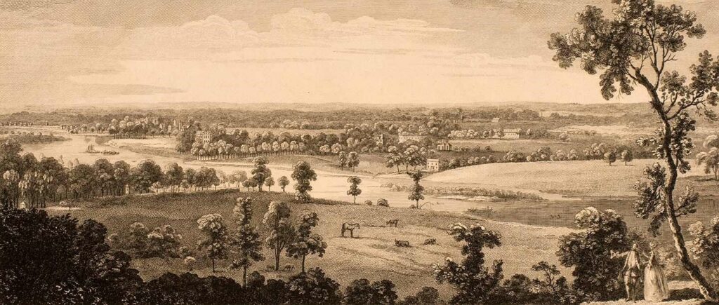
21st century redefinition, Antonio Joli, View from Richmond Hill
Scientific theory, the application of Euclidean geometrical principles, linear perspective and the visual pyramid to read area for instance, were instrumental in the shaping of a Landscape science. Linear perspective served to function as the technique adopted to represent three-dimensional spatial proportions on a two-dimensional surface based on the relative positioning of the observer externally, to the space. Towards the beginning of the fifteenth century, “Perspective” was referred to as a form of insight, or “a point of view” that facilitates perception or a way of seeing, similar to “prospect” or an outward view in space and in time. It contributed to the visual ideology of landscape as a form of perceiving nature in the English Renaissance, and towards the end of the sixteenth century.
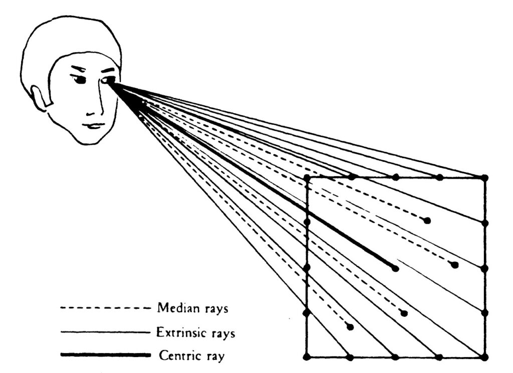
Prospect, Perspective and the Evolution of the Landscape Idea
The “scape” or the point of view of the “land” for the purpose of measuring area here is based on the observer, and his relative position in space which further determines the the form of objects depending on the angle and distance of vision. The eye of the observer is not constrained by external factors and exists as the sole determinate of the visual form. In this way, the artist or the cartographer through perspective or the use of the visual pyramid, creates the composition, and determines the specific time of the events which collectively narrates the point of view or perspective of the land, in effect controlling the extent of reality that is represented through documentation.
Alberti, Brunelleschi, Ambrogio Lorenzetti’s frescoes in the Palazzo Publico, Siena, 1340s and paintings on the walls of the Sistine Chapel – Christ giving to St. Peter the Keys to the Kingdom of Heaven, Peitro Perugion 1481 demonstrate the significance of the perspective in creating a point of view or a scape for the land.
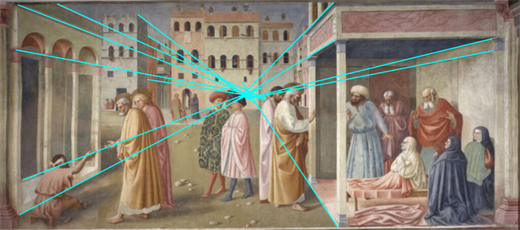
The Healing of the Cripple and the raising of the Tabitha, 1426 – 27
Alternatively, pre-perspective urban landscapes are significant forms of representations as they create a impression of the environment not from a fixed vantage point as the perspective does, but through a series of sequential views created through he perspective of the “pedestrian walking up the streets and seeing the buildings from many different sides.”
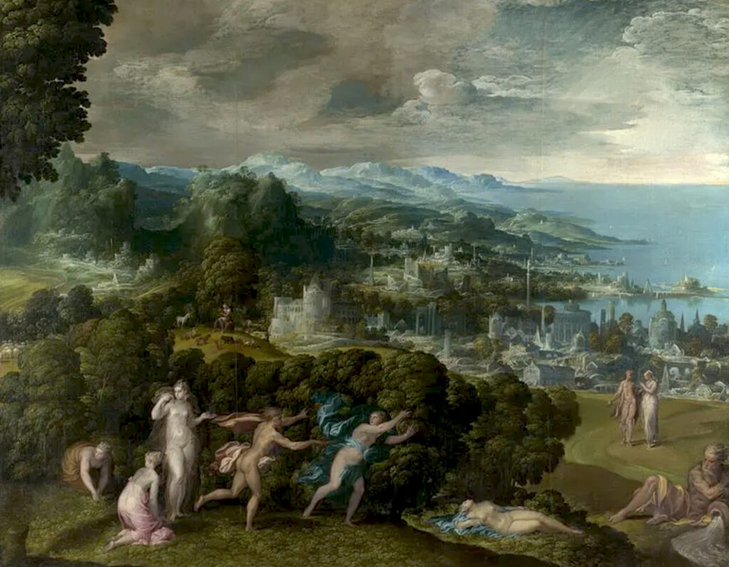
Niccolò dell’Abate, Orpheus and Eurydice (1550-1570)
Perugino’s ideal city represents a “formal monumental order” based on a precise geometry created ion the axis between the piazza and the circular temple at the centre. In this form of representation, the piazza, represents the city in its entirety with a geometrical centre.
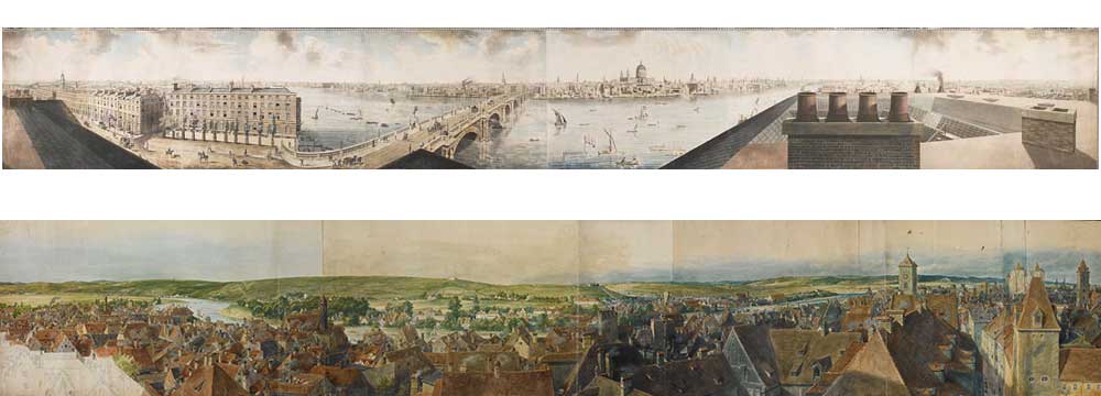
A representative form closer to the landscape painting was the “pianta prospectiva” or the bird’s eye view of cities popularised during the sixteenth century. In this regard, Jacobean de Barbari’s 1500 map of Venice serves as an ideological expression of urbanity with the viewpoint situated slightly above the city at a commanding distance. Similarly, Bruegel’s or Titan’s Panasonic landscapes create visual records of expansive earthscapes across seas. Land and mountains.
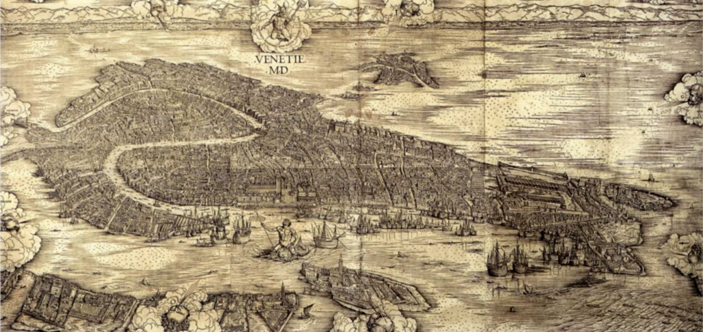
Pianta Prospectiva : The bird’s eye view of a city
Jacopo de Barbari, Map of Venice, 1500
The emergence of “realist landscape” in regions of upper Italy and Flanders denoted a reconfiguration in the relations between humans and the environment displaying a need for a new form of unison through enclosure. The shift in perception represented an increasing human need to control natural processes, the environment and the landscape. Consequently, this reflected in renewed relations between social groups and their landscape, familial and environmental bonds.
In contemporary culture, the development of Landscape through a humanist perspective, has focused more on its literary and linguistic implications as compared to visual and pictorial representations. This refutes the claim that Landscape retained on the discipline of geography solely through graphical and visual devices in the form of cartographic maps.
These contradictions within the discipline, for example, the two opposing perspectives stemming from scientific and humanist origins, and alternatively, the preference for either linguistic or graphic representation bearing greater significance and potential, further serves to reinforce their distinct roles and relationships under the umbrella of Landscape design, and define an ideology of perception through it.
Realist Landscapes : Relations between social groups, their terrain and habitat